The design and installation of geotechnical instrumentation in Bunbury follows the framework of AS 4678 for earth retaining structures and AS 1726 for subsurface investigation, but the local geology demands a tailored approach. Bunbury sits on the Swan Coastal Plain with deep sands overlying the Leederville Formation and, in some areas, estuarine deposits from the Leschenault Inlet. This layering makes it essential to install piezometers and inclinometers at precise depths to capture pore pressure response in the sand layers and potential movement in the softer clay lenses. Before we even begin installation, we cross-reference the geotechnical model with the intended structural behaviour, ensuring each sensor answers a specific design question rather than just collecting data for the sake of it. Pairing this with a [MASW survey](/masw-vs30/) helps define shear wave velocity profiles that inform both instrumentation depth and seismic site classification.
A single inclinometer reading every 24 hours can miss the onset of a slip surface; continuous monitoring with automated dataloggers is the standard we apply in Bunbury.
Approach and scope
Site-specific factors
A few years ago we were called to a site near the Bunbury Port where a new wharf approach was showing unexpected lateral movement. The original design included manual inclinometer readings every two weeks, but after a 48-hour rain event the sand fill behind the sheet pile wall lost suction and the deflection rate jumped. Without continuous instrumentation, the movement went undetected for nearly a week. We installed an array of vibrating wire strain gauges on the piles and in-place inclinometers with hourly reporting, which caught the acceleration early enough to install relief drains before the wall reached yield. That experience reinforced a lesson: in Bunbury's coastal fill environments, automated geotechnical instrumentation is not a luxury but a safety-critical system.
Regulatory framework
AS 4678:2002 Earth-retaining structures (instrumentation requirements), AS 1726:2017 Geotechnical site investigations, AS/NZS 1170.2:2011 Structural design actions (wind loads for sensor masts)
Related technical services
Piezometer and Pore Pressure Monitoring
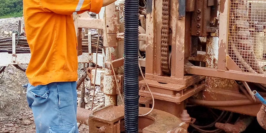
Installation of vibrating wire and pneumatic piezometers in boreholes and standpipes, with dataloggers configured for Bunbury's seasonal groundwater fluctuations. We seal each installation with bentonite grout to prevent vertical leakage along the casing.
Inclinometer and Deformation Monitoring
Permanent and temporary inclinometer casing installations for retaining walls, embankments, and excavation batters. We provide baseline surveys, periodic readings, and automated real-time alerts when movement exceeds predefined thresholds.
Settlement and Heave Monitoring
Hydraulic settlement cells, magnetic extensometers, and surface survey arrays for structures and fills. Data is compiled into weekly reports with trend analysis, comparing measured settlement against predicted values from the geotechnical model.
This service complements our laboratory testing work for a complete project analysis.
Typical parameters
Top questions
How long does a typical geotechnical instrumentation installation take in Bunbury?
A standard array of three vibrating wire piezometers and two inclinometer casings takes two to three days on site, including drilling, sensor installation, backfilling, and datalogger commissioning. Larger projects with settlement cells and strain gauges can extend to five or six days.
What sensors are best for monitoring retaining walls in Bunbury's sandy soils?
Inclinometer casings installed behind the wall provide lateral movement profiles, while vibrating wire piezometers placed at the wall toe measure pore pressure buildup after rainfall. Strain gauges on the wall itself give direct load readings if the structure is steel or reinforced concrete.
Is real-time data transmission available for remote sites around Bunbury?
Yes, we offer 4G cellular telemetry with a LoRa backup option for sites with intermittent coverage, such as near the Leschenault Peninsula or along the Collie River. Data uploads to a secure cloud platform accessible by the project team via web dashboard or API.
What is the typical cost range for a geotechnical instrumentation program in Bunbury?
For a medium-sized project involving six to ten sensors with dataloggers and three months of monitoring, the cost typically falls between AU$4,150 and AU$6,480. This includes design, installation, calibration certificates, and weekly data reports. Larger programs with telemetry and longer durations are quoted per scope.