Under AS/NZS 1170.4:2007, seismic site classification in Bunbury requires reliable VS30 values, particularly given the city's position on the Swan Coastal Plain with deep alluvial deposits overlying the Leederville Formation. Bunbury's proximity to the Darling Fault zone means ground motion amplification is a real concern for medium-to-high-rise developments along the coast. We deploy multichannel analysis of surface waves (MASW) to derive 1D and 2D shear wave velocity profiles without boreholes, complementing this with microtremor HVSR resonance checks where soft sediment thickness exceeds 30 metres. The method is non-invasive and works well on the sandy soils and limestone caprock typical of the Bunbury area.
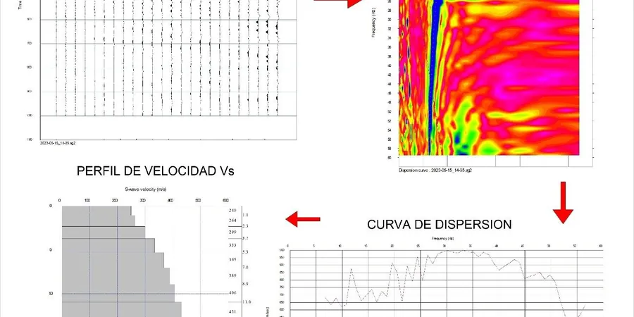
MASW surveys in Bunbury capture stiffness profiles continuously, identifying velocity inversions that a single borehole would miss entirely.
Approach and scope
Site-specific factors
The 24-channel seismograph we deploy in Bunbury is towed behind a lightweight all-terrain vehicle, allowing us to cover linear arrays along roads, vacant lots, and even beachfront dunes without disturbing the surface. Each receiver is a vertical-component 4.5 Hz geophone coupled to the ground via a small spike plate — no drilling, no grout, no restoration cost. This setup lets us acquire a 92-metre spread in under 10 minutes, then we move the entire array forward by half the spread length for continuous coverage. The real value in Bunbury is the ability to test multiple sites in a single day, giving developers a defensible VS30 value for every lot before foundation design begins.
Service video
Regulatory framework
AS/NZS 1170.4:2007 Structural design actions – Earthquake actions, NEHRP Recommended Provisions (FEMA P-750) – Site classification, AS 1289/D4428M-14 Standard test method for crosshole seismic testing
Related technical services
2D MASW Multi-Line Profiling
Multiple parallel arrays along a grid or linear corridor, producing a 2D cross-section of shear wave velocity to 40 m depth. Ideal for seismic microzonation of new subdivisions in Bunbury's coastal suburbs, where sand dunes overlie clays of varying thickness.
Standalone VS30 for Site Classification
Single 1D MASW sounding centred on the building footprint, sufficient to assign AS 1170.4 subsoil class (A–E) for structures up to 15 storeys. Typically combined with a single borehole for soil identification, but the VS30 value comes entirely from the surface wave inversion.
Typical parameters
Top questions
What is the difference between MASW and the standard SPT for determining VS30 in Bunbury?
MASW measures shear wave velocity directly from surface wave dispersion, giving a continuous profile to 30 m or more. SPT-derived VS30 relies on empirical correlations that are often inaccurate for the cemented limestone layers and variable sands found in Bunbury. MASW also avoids drilling costs and access restrictions.
How much does a MASW / VS30 survey cost for a typical Bunbury residential project?
For a standard 1D VS30 survey on a single lot in Bunbury, expect a professional fee between AU$2,950 and AU$4,500, depending on site access, number of arrays, and whether a borehole is required for soil classification. This includes field acquisition, inversion, and a certified report with site class assignment.
What site classes are most common in Bunbury, and how does MASW help identify them?
Bunbury predominantly falls into site classes C (shallow soil) and D (deep soil) under AS 1170.4, with isolated areas of class B near limestone ridges. MASW identifies the depth to engineering bedrock (Vs > 1500 m/s) and the average velocity in the upper 30 m, which directly determines whether a site is class C or D — a distinction that affects design spectra significantly.
Can MASW be used on sloping sites or areas with limited space in Bunbury?
Yes, we adapt the array geometry to fit irregular lots, using shorter geophone spacings (1–2 m) and fewer channels if needed. For steep slopes in the hinterland around Bunbury, we deploy a rolling array that moves incrementally, maintaining a minimum 46 m spread to achieve 30 m depth. Urban sites with underground services require pre-scan clearance, but the method is safe and non-destructive.