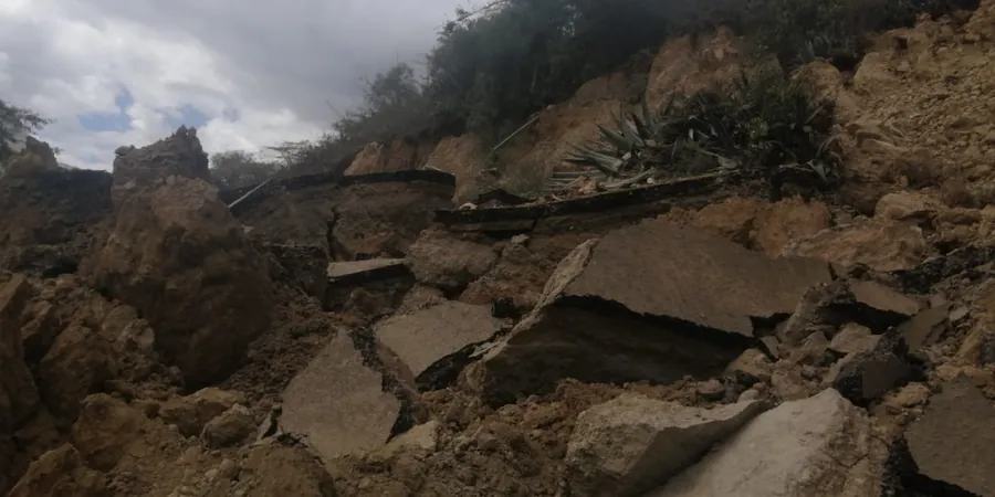
Bunbury sits on a mix of Tamala limestone and quaternary sands, part of the Spearwood dune system that runs along the Leschenault Estuary. The water table here can sit just 2 to 4 metres below surface after winter rains, which directly raises pore pressures in the sandy slopes above the estuary. When developers cut into these dunes for new subdivisions along the Preston River or near Ocean Drive, the exposed faces often lose the root reinforcement from the original tuart woodland. We step in with a phased approach: walkover mapping of tension cracks and seepage zones, then targeted boreholes with piezometers to measure the actual phreatic surface. Complementing this, we run slope stability models that account for the cemented layers within the Tamala limestone, which can behave as perched aquifers and trigger shallow translational slides. The typical Bunbury lot on a 15- to 20-degree slope needs a factor of safety above 1.5 per AS 4678, and we have yet to find a site here where a standard limit-equilibrium analysis alone tells the full story.
A cut slope on one side of the street can be stable while the neighbour fails, simply because the Tamala limestone lens pinches out laterally.
Approach and scope
Site-specific factors
A common mistake we see in Bunbury is when the earthworks contractor strips the topsoil and immediately cuts a batter to the final angle without waiting for a geotechnical assessment. The exposed sand dries out and looks firm for a week, then the first 30-millimetre rain event saturates the toe and the whole face slumps into the drainage swale. That reactive clean-up costs more than the original assessment would have. Another error is assuming that because the lot next door held stable, yours will too — the limestone lenses and root networks vary within metres. A proper landslide assessment in Bunbury must include monitoring of the groundwater response after the cut is made, not just a pre-construction desktop study. We install simple standpipe piezometers and return after the first significant rain to re-check the phreatic surface before signing off on the retaining wall design.
Service video
This service complements our laboratory testing work for a complete project analysis.
Regulatory framework
AS 4678-2002: Earth-retaining structures (slope stability limit states), AS 1726-2017: Geotechnical site investigations (logging and sampling), AS/NZS 1170.2:2021: Wind actions (relevant for trees on slopes), AS 2870-2011: Residential slabs and footings (adjacent fill stability)
Related technical services
Slope Stability Analysis & Modelling
Limit-equilibrium analysis using Bishop, Spencer, and Morgenstern-Price methods on cross-sections derived from borehole logs. We calibrate shear strength parameters from triaxial tests on undisturbed samples of the Tamala limestone and Spearwood sand. The output includes factor-of-safety contours, critical slip surfaces, and recommended batter angles for cuts up to 12 m high.
Groundwater & Piezometer Monitoring
Installation of standpipe and vibrating-wire piezometers at strategic depths within the slope profile. We monitor the phreatic response through at least one wet season and provide a pore-pressure time series that feeds directly into the stability calculation. This is critical in Bunbury where winter rainfall can raise the water table by 2 metres in a week.
Typical parameters
Top questions
What triggers a landslide in Bunbury's dune soils?
The main trigger is winter rainfall saturating the upper sand layers above a less permeable limestone lens or a root-bound horizon. Once the pore pressure exceeds about 45% of the overburden stress, the effective stress drops and the sand loses its apparent cohesion. Shallow translational slides of 1 to 2 metres depth are the most common failure mode. We also see toe erosion from the Leschenault Estuary in properties backing onto the water.
How much does a landslide assessment cost in Bunbury?
For a standard residential lot on a 15-degree slope, the cost ranges between AU$1.750 and AU$6.420 depending on the number of boreholes, piezometer installation, and laboratory testing. A larger commercial subdivision on the Spearwood dunes with multiple cut slopes will be at the upper end. The range includes the walkover, drilling, lab work, stability analysis, and a report with a signed geotechnical certificate.
Do I need a landslide assessment for a retaining wall in Bunbury?
Yes, if the retaining wall is more than 1 metre high and the slope behind it exceeds 10 degrees, AS 4678 requires a stability assessment that considers both the wall and the natural slope. We have seen cases in Bunbury where a 1.8-metre block wall failed because the backfill was placed on a saturated Bassendean sand layer without a drainage blanket. The assessment identifies the failure surface and allows the engineer to design the wall height and drainage accordingly.